Posts
Firefly maps are promoted and described by John Nelson who published a post in 2016 about its characteristics. However, these types of maps are linked to ArcGIS, which has led me to try to recreate them in R.
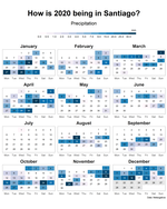
Recently I was looking for a visual representation to show the daily changes of temperature, precipitation and wind in an application xeo81.shinyapps.io/MeteoExtremosGalicia (in Spanish), which led me to use a heatmap in the form of a calendar. The shiny application is updated every four hours with new data showing calendars for each weather station.